
Smart Growth District FAQs
In the effort to provide factual information regarding the proposed Smart Growth District we have posted answers to the following frequently asked questions (FAQ):
Frequently Asked Questions:
Is the proposed 40R District being driven by private developer interests, such as MINCO Corporation or others?
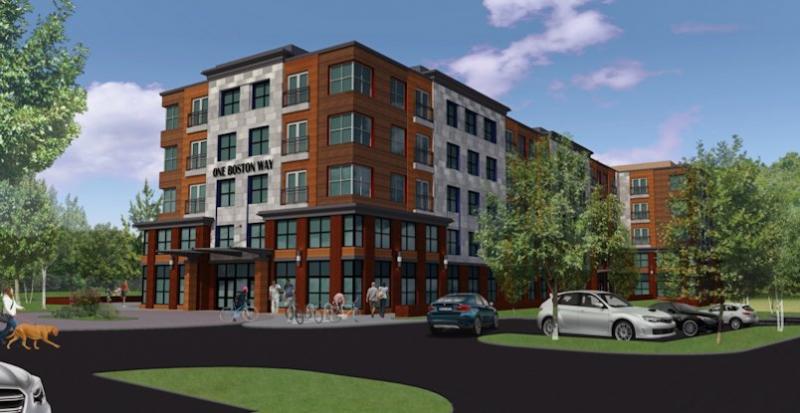
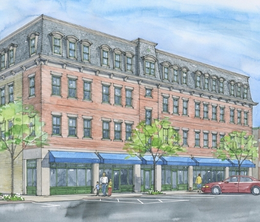
Answer: NO. The proposed “Smart Growth” District is consistent with over a decade’s worth of community planning for such a “transit-oriented” mixed-use neighborhood adjacent to the MBTA Commuter Rail Station. The City’s 2004 Strategic Land Use Plan, draft Master Plan Update and the Merrimack Valley Priority Growth Strategy (a regional land use plan for the Merrimack Valley, developed by the Merrimack Valley Planning Commission) all recommend the adoption of a so-called 40R Smart Growth District or similar Ordinance for redevelopment of properties around the MBTA Commuter Rail Station. Several 2010 and 2015 letters from the Mayor, City Council, Planning Board, Affordable Housing Trust and Office of Planning & Development evidence local support for this new vision of an underutilized corner of the City. The Massachusetts Bay Transit Authority (MBTA) solicited proposals from developers interested in working with the City to realize its vision for “transit-oriented development” around the train station. MINCO Corporation was the first developer to express interest in permitting a mixed-use building consistent with this local vision, by redeveloping one of the underutilized MBTA Station parking lots, designated surplus land by the MBTA several years ago. As such, it is likely that MINCO’s project for the 1 Boston Way site adjacent to the MBTA Station (conceptual rendering below, and still subject to review by the Newburyport Planning Board) will be the first project permitted under the new Ordinance.
If the proposed 40R District is adopted, will the City cede local power to the State regarding future development near the MBTA station?
Answer: NO. The City of Newburyport will be adopting the proposed 40R District through the same procedures used to adopt local Zoning Ordinances. As such, a City Council vote is required to adopt the proposed 40R District and any amendments thereto. While the Commonwealth of Massachusetts is required to review the City’s proposed 40R District Ordinance for the purposes of determining what “incentive” payments the City should receive for adopting a so-called “Smart Growth District,” the state does not take control over development from the City within the District. Even after adoption of the Ordinance the Newburyport Planning Board becomes the Plan Approval Authority for any projects proposed by private developers within the District and all development plans must adhere to the Design Standards contained in the Ordinance before any construction can begin.
The proposed 40R District would mandate that developers set aside at least 25% of all new residential units as “affordable units,” and therefore reserving residential units for individuals and households making less than 80% of the Area-wide Median Income (AMI). If the City adopts this Ordinance as proposed, can the state change these previously agreed upon provisions at any time?
Answer: NO. The City of Newburyport retains control over local zoning, including the proposed 40R District regulations. The state cannot unilaterally impose higher residential “buildout” or an increased number of affordable housing units within the 40R District. As explained above, the City Council retains local control over zoning regulations and development potential within the 40R District.
What is the anticipated maximum “buildout” potential of the proposed 40R District? How quickly could this development occur, and what provisions are in place to ensure that the City can handle the projected increase in new residents from 40R development?
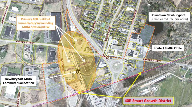
Answer: The City’s Office of Planning & Development has determined that the maximum buildout within the proposed 40R District is 540 new units (6.74% of the City’s existing housing stock), most of which would be one and two-bedroom units. This maximum buildout is according to formulas developed by the state’s Department of Housing & Community Development and assumes that all parcels of land within the 40R District would be developed as efficiently as possible. The reality is that some parcels of land within the proposed District would not be redeveloped at all, and others would be redeveloped in a manner that is less than efficient due to wetlands constraints and the relatively small size of some parcels, greatly limiting their redevelopment potential. With these realistic constraints in mind the City’s Office of Planning & Development has determined that the maximum buildout that is likely to occur in the District (over several decades) would be closer to 400 new units (4.99% of the City’s existing housing stock - roughly 5%). This new growth is most likely to occur immediately surrounding the MBTA Commuter Rail Station (as depicted in the image below). This potential development would take several decades to be realized, even if developer interest is sustained that long, due to complex land assemblage, regulatory, permitting, financing, and other developer constraints.
The City’s Office of Planning & Development has reviewed infrastructure requirements for the proposed 40R District with the Department of Public Services and has determined that there is more than sufficient capacity at the City’s Water and Wastewater Treatment Plants to provide for additional residential and commercial growth within the proposed 40R District. The City is currently selecting an engineering firm to design a new Lift Station on Graf Road which is already handling sewer flows in excess of its original design capacity. This Lift Station pushes wastewater over the hill (where the Bartlett Mall is located) to the Wastewater Treatment Plant on Water Street. This Lift Station must be upgraded in the next few years regardless of the proposed 40R District due to existing operational safety issues as well as future growth in the Newburyport Business Park and the larger “catchment” area shown in the map below. To reduce the cost of this infrastructure upgrade the City is applying for a so-called “MassWorks Infrastructure Grant” from the Commonwealth of Massachusetts. Adoption of the 40R District would give the City a strong competitive advantage in this grant program because the state seeks to target infrastructure funding toward compact “transit-oriented” neighborhoods with increased capacity for job creation (i.e. the adjacent Newburyport Business Park). The City is on target to begin upgrade of the Graf Road Lift Station in 2016.
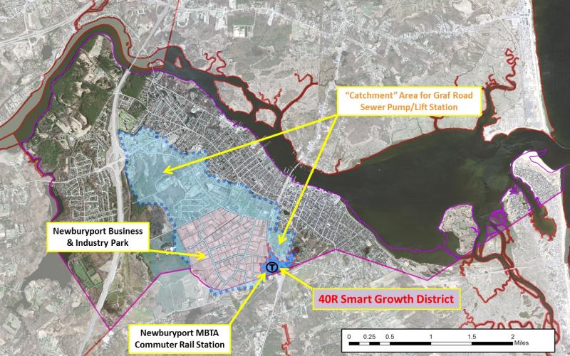
The Graf Road Pump Station must be upgraded regardless of the 40R District due to current safety concerns, operational deficiencies, and additional demand generated in a significant portion of the City, as shown in this map.
The City’s Office of Planning & Development has determined that the maximum buildout permitted within the proposed 40R District is 540 new units (per state formulas), which could (at full buildout, at least several decades into the future) result in an additional 155 new school-age children, distributed throughout the Newburyport Public Schools.How would the City address the additional cost and space necessitated by these potential new students?
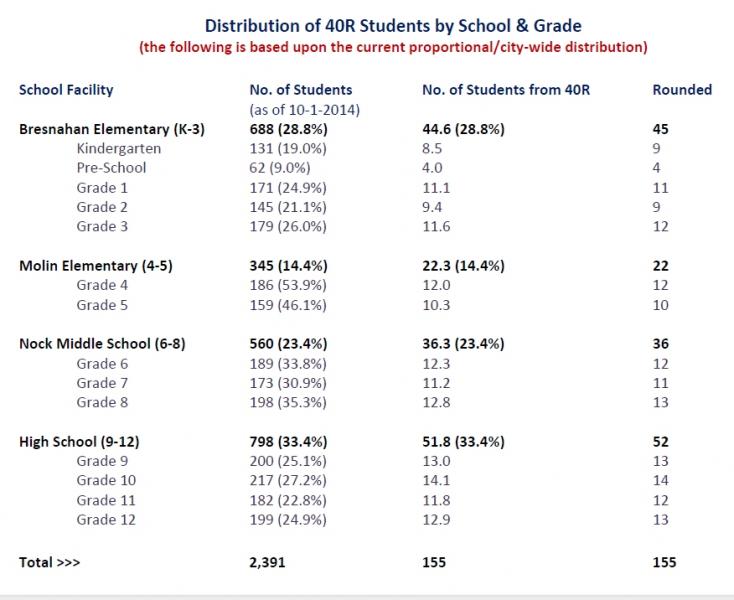
Answer: The above spreadsheet depicts the anticipated distribution of these potential new school-age children throughout the Newburyport Public Schools, based on existing distribution patterns. Although the suggestion has been made that there is no space for additional students at the Nock-Molin School and High School, enrollment projections based on current trends, provided by the School Department indicate a trend toward decreased student enrollments beginning in the younger grades and shifting upward through the High School in the coming years. With only a few students being added to each classroom (even at full buildout) there is no need to construct a new school building for these additional students. Enrollment projections indicate that there will be adequate space in the individual grades and classrooms to accommodate any potential students from the 40R District. In review of the potential school-age children that could be generated from the proposed 40R District, School Superintendent Susan Viccaro has offered the following:
“I have reviewed the data on 40R and its potential impact on the Newburyport Public Schools enrollment. I do not believe that there will be any negative impact on enrollment as we look to the foreseeable future. I still have room in all buildings and our class sizes are currently good. We are opening Choice in kindergarten next year and will open subsequent grades in the following progression:
Year Grade
2015-2016 K
2016-2017 1
2017-2018 2
The plan will be to continue to open the next grade level as enrollment is declining at the younger grades and appears to be the start of a state trend.”
A financial (fiscal impact) analysis prepared by the City’s Finance Director indicates that the proposed 40R District will result in an increase in annual tax revenues regardless of the overall buildout, due in part to the state’s obligation to provide yearly reimbursement to the City for any net increase in the cost of educating new students, pursuant to M.G.L. Chapter 40S. Although speculation has been made by District opponents that the state might one day default on its obligation to provide “40S payments” to the City, there have been no such defaults to date for any other communities requesting reimbursement from the State. The following table summarizes 40S payments received to date by local municipalities as reimbursement from the Massachusetts Department of Revenue (DOR):
FY’2014
Lakeville $253,125
Lunenburg $183,618
FY’2013
Lakeville $131,271
FY’2012
Lakeville $182,309
FY’2011
Chelsea $76,444
Lakeville $166,497
FY’2010
Chelsea $276,314
Lakeville $87,385
Note: 40S Reimbursements from the DOR are provided only to those communities with actual students generated from 40R developments. To date only the above indicated communities have applied for 40S reimbursements based on their actual buildout and occupancy.
Would the proposed 40R District result in increased cost to the City for services such as road maintenance and repair, snow and trash removal, police, fire and ambulance calls?

Answer: The proposed 40R District (depicted on the above referenced map) is located around the MBTA Commuter Rail Station and the Route One Traffic Circle, an area which is already developed. The proposed 40R District simply allows redevelopment of this area in a character more consistent with Downtown Newburyport, including multi-story buildings with commercial uses on the first floor and residential uses above. As all parcels of land within the 40R District are served by existing roads there would be no increased cost for routine road maintenance or snow removal. Any snow, trash or recycling pickup on private property would be the responsibility of the private developer, property owner or residents.
As the anticipated buildout within the 40R District is less than 5% of the existing housing stock in Newburyport, with a relatively small increase in commercial space, it is unlikely that the District will have any notable increase in demand for police, fire or ambulance calls. Any incremental increase in the typical requests for emergency response services would be more than offset by the additional 40R District revenues.
In response to the City’s request, the Merrimack Valley Planning Commission (MVPC) will be undertaking a comprehensive study of the Route One Corridor during the next year to determine what options are available for modifying the design of this state-controlled highway to make it more pedestrian and bike-friendly (i.e. a “complete streets” approach) rather than a barrier through the City. This will require coordination with the Massachusetts Department of Transportation (MassDOT), which retains control over this roadway. Initial discussions have involved reducing the excessive size of the Route One Traffic Circle and converting the two-lane Route One corridor into a single-lane tree-lined parkway with more designated pedestrian and bike crossings. MVPC is currently finalizing a Traffic Analysis for the 40R District to respond to the concern raised that the District roadways be adequate to support the potential new development. In general the existing roadways have enough capacity to support the projected new growth. Still, the City and MVPC are pursuing all options to shrink the Route One Traffic Circle, and make the Route One Corridor as a whole more pedestrain and bike-friendly.
What are the parking requirements for the proposed 40R District, and how will the Planning Board ensure that resident parking and traffic congestion will not spread into the Back Bay neighborhood?
Answer: The proposed District requires at least one parking space per residential unit, all of which must be provided by the developer on-site. Additional requirements for non-residential uses are contained in the District Ordinance. Residents in new housing around the MBTA Commuter Rail Station will not want to park their cars across the Route One divided highway, which is an inherent barrier protecting the Back Bay neighborhood. Traffic congestion is a in fact a byproduct of too many vehicles, encouraged by conventional sprawl zoning and excessive distances between land uses. The typical requirement for two parking spaces per unit (in single and two-family suburban homes) is not necessary for a transit-oriented neighborhood whose residents are seeking multi-modal transportation options to Boston (via the MBTA Commuter Rail), Downtown Newburyport (via the Clipper City Rail Trail) and other locations (via the MVRTA bus system). The proposed “Smart Growth” District is an alternative to conventional sprawl subdivision neighborhoods and strip-malls. The District gets its name from the state statute that encourages municipalities to adopt these new compact zoning districts around train stations and other multi-modal transportation access. Post WWII development in the Commonwealth and the nation, particularly 1960-1980, were defined by auto-centric development patterns sprawling outward across the landscape ensuring societal dependence on vehicular transportation and its resultant problems including traffic congestion, smog, increased distances to places of work, and health effects such as obesity. In the past two decades a nation-wide trend has returned to “neo-traditional” development patterns, based upon infill and redevelopment of areas like the proposed 40R District, where residents are looking for alternative access to work and play, and less dependence on vehicle trips and miles traveled. It is this growing segment of the population that will be attracted to the 40R District. Historic Newburyport is a compact community, and any redevelopment at the MBTA Commuter Rail Station should be consistent with that pattern. The proposed 40R District will convert an underutilized area of the City into a revitalized tax base for the City, ensuring long-term financial success for the adjacent Business Park and the City as a whole.
 The above illustration depicts a newly constructed building in downtown Westbrough following traditional design standards for mixed-use buildings. The proposed 40R District would allow the construction of similar buildings to replace the vacant and underutilized properties around the MBTA Train Station and Route One Traffic Circle.
What’s wrong with the existing development pattern around the MBTA Commuter Rail Station and Route One Traffic Circle? What better alternative does the proposed 40R District provide?
Answer: The proposed 40R District covers an area of the City that is already developed with conventional “sprawl” strip malls and auto-centric uses. The 40R District includes many properties that are underutilized and are therefore ideal for the kind of redevelopment allowed by the proposed 40R District. These alternatives to the existing development pattern within the area would result in architecture that is more consistent with the character of Downtown Newburyport. (See illustrative images above and below.) Redevelopment of properties within the 40R District would have little (if any) impact on the City, but would result in additional tax revenue to support City operations while creating a neighborhood around the MBTA Commuter Rail Station that is more attractive and consistent with the character of other areas in Newburyport, in lieu of the miscellaneous assortment of strip-mall style uses currently dominating this gateway to the City.
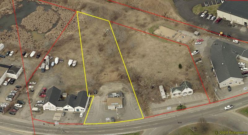
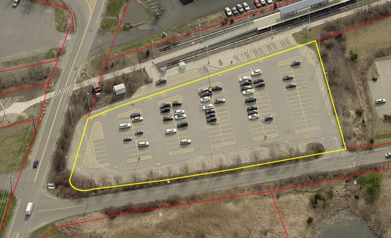
Examples of existing properties within the proposed 40R District:
9. What is the difference between 40R development and 40B development? And why would we want a 40R District in lieu of 40B developments?
Answer: Massachusetts General Laws (MGL) have adapted over time in the effort to encourage the creation of affordable housing units. MGL 40B, adopted several decades ago allows developers to circumvent local zoning and design requirements if they designate at least 25% of their housing units as deed restricted affordable units. Alternatively, MGL 40R encourages the creation of so-called Smart Growth zoning districts (such as the one proposed in Newburyport) whereby multi-family housing and mixed-use buildings are allowed through a streamlined permitting process, but still subject to local review of site and building design standards.
The proposed 40R District provides an alternative to so-called “40B” development projects whereby developers can supersede local zoning requirements in almost every respect, as long as they provide set aside at least 25% of all new residential units as “affordable,” and therefore reserved for individuals and households making less than 80% of the Area-wide Median Income (AMI). By establishing an “as-of-right” allowance for residential and mixed-use development, private developers are given an incentive to use this 40R District zoning and permitting process rather than undertake a more complicated and contentious permitting process. All development projects permitted under the 40R regulations will require approval by the Newburyport Planning Board to ensure consistency with architectural and site design standards codified in the Zoning Ordinance. Without adoption of a 40R District there is greater incentive for developers to pursue a 40B permitting process where the City has little (if any) control over the ultimate density, site and architectural design. An additional benefit of adopting the proposed 40R District is the requirement that any new “affordable” units be affordable in perpetuity. 40B developments often contain units that are designated affordable only for a period of thirty (30) years, as a more permanent restriction cannot be mandated with certainty by the local community. As such, 40B developers remove local zoning constraints with little long-term benefit to the municipality or the Commonwealth. By comparison, the proposed 40R District Ordinance requires that all developments provide units that are affordable in perpetuity, thereby meeting a high local demand for affordable housing. These permanently affordable units will be counted on the City’s Subsidized Housing Inventory (SHI) which in turn will assist the City in defending against any undesirable 40B type projects proposed in the future, consistent with state regulations.
Have Additional Questions?
If you have any further questions regarding the proposed 40R Smart Growth District, please contact:
Andrew R. Port, Director of Planning & Development
Phone: (978) 465-4400
Email: aport@cityofnewburyport.com